Thanatos Weather
Wednesday, Jul 01, 2026 11:58:18

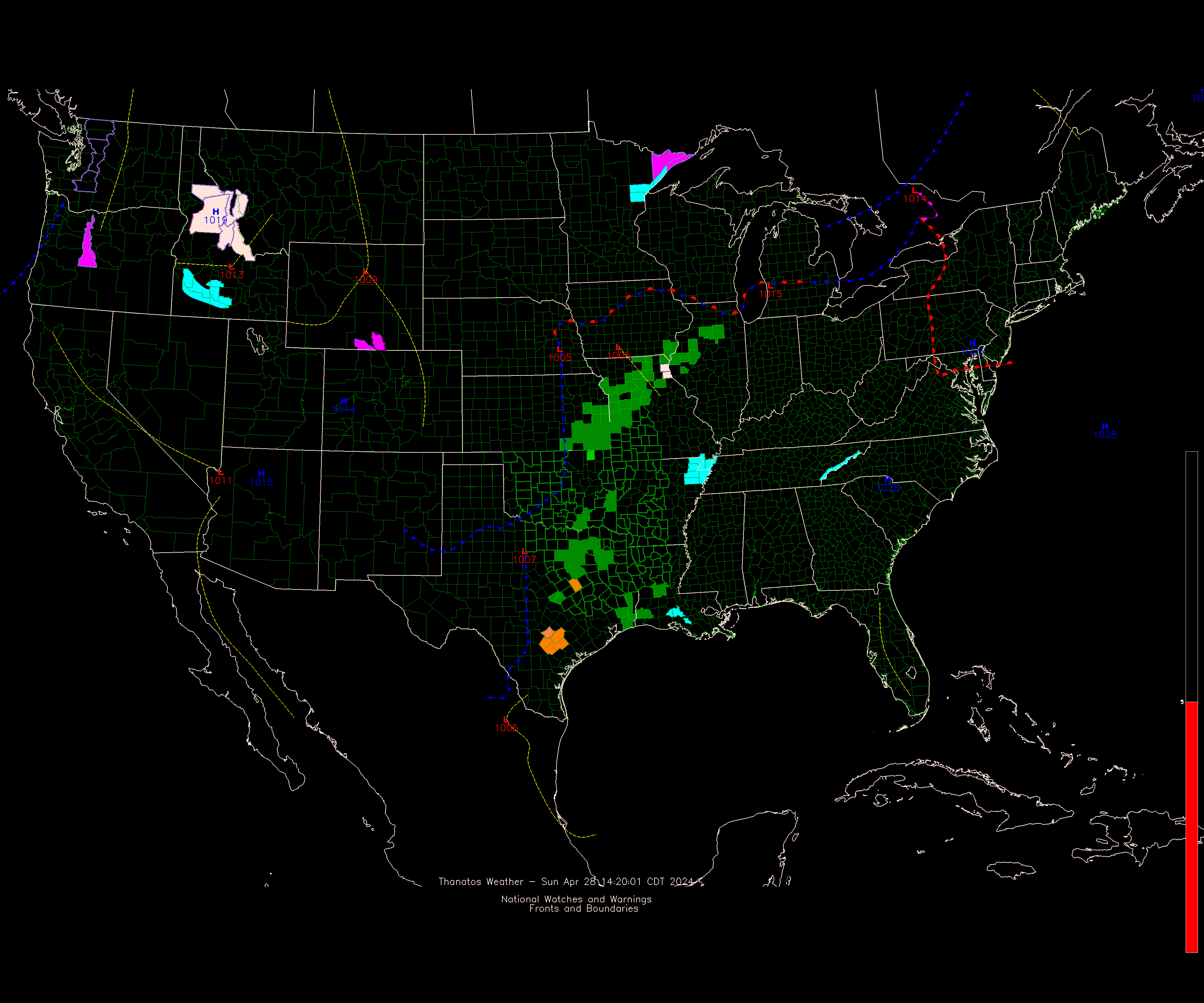
Active Watches, Warnings, and Advisories
Product Office Expire Time
Heat Advisory Tulsa 2026-07-01 20:00
Heat Advisory Tulsa 2026-07-02 20:00

Recent Local NWS Text Products
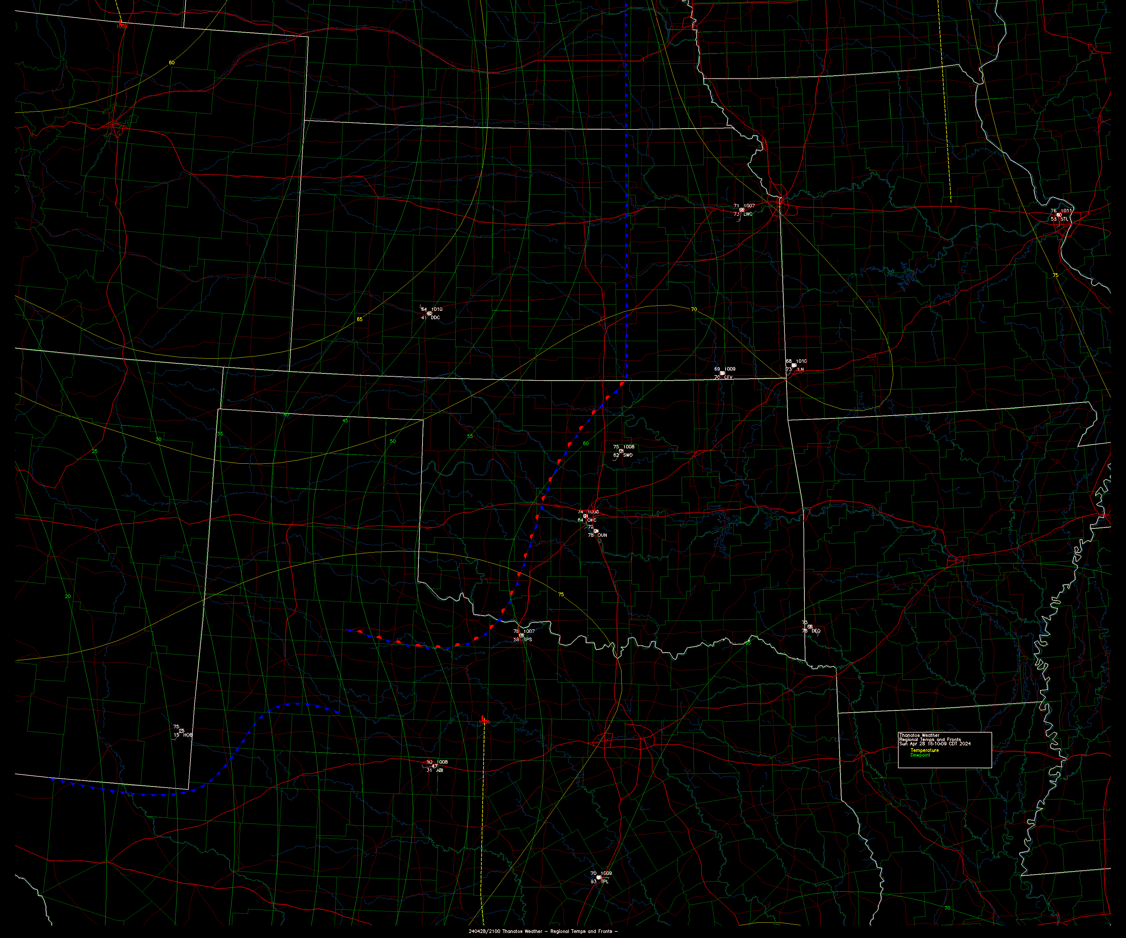
Product Qty Most Recent
Norman
Severe Thunderstorm Warning 1 06/30/2026 18:02
Special Weather Statement 1 06/30/2026 18:43
Severe Weather Statement 1 06/30/2026 18:43
Radar Notices 3 07/01/2026 10:20
Local Storm Report 2 06/30/2026 18:08
Zone Forecast 4 07/01/2026 05:37
Area Forecast 6 07/01/2026 05:04
Tulsa
Urgent Weather Statement 2 07/01/2026 11:10
Flood Statement 4 07/01/2026 08:26
Hazardous Weather Outlook 4 07/01/2026 05:20
Zone Forecast 8 07/01/2026 11:18
Area Forecast 8 07/01/2026 11:38
Amarillo
Severe Thunderstorm Warning 6 06/30/2026 19:14
Special Weather Statement 8 06/30/2026 23:41
Severe Weather Statement 7 06/30/2026 19:29
Watch Notification 3 06/30/2026 22:00
Flash Flood Warning 3 06/30/2026 18:54
Flood Statement 6 06/30/2026 22:23
Local Storm Report 4 06/30/2026 19:19
Hazardous Weather Outlook 2 07/01/2026 00:45
Zone Forecast 14 07/01/2026 11:47
Area Forecast 5 07/01/2026 06:34
Dallas/Fort Worth
Radar Notices 1 06/30/2026 11:16
Zone Forecast 9 07/01/2026 11:54
Area Forecast 4 07/01/2026 05:16
Storm Prediction Center
Convective Outlook - Day 1 5 07/01/2026 07:37
Convective Outlook - Day 2 2 07/01/2026 01:03
Convective Outlook - Day 3 2 07/01/2026 02:35
Convective Outlook - Days 4-8 1 07/01/2026 04:02
Mesoscale Discussion 21 07/01/2026 11:05
Watch Status Report 23 07/01/2026 11:40
NWS NCEP Central Operations
SDM Administrative Message 11 07/01/2026 11:56
Products are removed after about 24 hours.

Regional Conditions
Temp Wind Location
87°F S 11 mph G 23 Ada
84°F S 10 mph G 18 Ardmore
87°F S 18 mph Altus/Quartz Mtn Regional
87°F S 18 mph G 25 Chickasha Municiple
84°F S 19 mph Clinton
87°F S 16 mph Duncan - Halliburton Field
84°F SW 18 mph G 27 Frederick
82°F S 21 mph G 29 Gage
0°F S 14 mph G 20 Claremore Regional
87°F SW 17 mph G 26 Guthrie
87°F SW 24 mph G 42 Guymon
87°F SSW 14 mph G 25 Lawton Municiple
86°F S 11 mph G 19 Muskogee
87°F SW 12 mph G 19 McAlester Regional Airport
87°F S 17 mph G 26 Oklahoma City - Will Rogers
86°F S 128 mph G 21 Norman - Max Westheimer
87°F S 11 mph G 24 Ponca City
89°F S 12 mph G 18 Poteau
89°F S 17 mph G 21 Shawnee Municiple
89°F SW 12 mph G 21 Stillwater
87°F S 18 mph G 24 Tulsa International Airport
82°F S 20 mph G 31 Dodge City
86°F S 13 mph Dallas/Fort Worth, TX
82°F S 18 mph G 25 Wichita, KS
89°F S 21 mph G 29 Wichita Falls, TX
77°F S 19 mph Lubbock, TX
87°F S 5 mph Fort Smith, AR
80°F S 20 mph G 28 Amarillo, TX
86°F SW 16 mph G 26 Joplin, MO


Resources


Current Conditions
Norman - Max Westheimer
86°F
Clouds Sky Clear
Wind S 128 mph G 21
Pressure 29.99 in
Dewpoint 69.8°F
  Humidity 58%
  Heat Index 92°F
11:45
Visibility 10 Miles
07/01/2026  
Oklahoma City - Will Rogers
87°F
Clouds Scattered at 25000ft
Wind S 17 mph G 26
Pressure 29.99 in
Dewpoint 68.0°F
  Humidity 53%
  Heat Index 92°F
11:52
Visibility 10 Miles
07/01/2026  

Current Radar
Oklahoma City (Norman), OK
Image Age: 151 seconds - Scan Time: 421 seconds


Available NEXRAD Radar Sites
SiteLocationVCPStatusAvailable Images
KFWSFt.Worth,TX35 Maint. Mandatory ReflectivityVelocity
KTLXOklahoma City (Norman), OK35 Operational ReflectivityVelocity
KFDRFrederick, OK35 Operational ReflectivityVelocity
KINXTulsa (Inola), OK35 Maint. Mandatory ReflectivityVelocity
KVNXVance AFB, OK35 Operational ReflectivityVelocity
TOKCOklahoma City, OK (TDWR)90 Operational ReflectivityVelocity


Page Loaded at: 2026-07-01 11:58:18 -- Client Address: 216.73.217.43 -- Refresh Time: 280 seconds -- Load Time: 0.0956 seconds